Live Environmental Data (NB: these resources are only accessible from the internal Lowell network)
- DCT WRS (Weather Reporting System) Webpage (http://dcs.lowell.edu:8016/WRSView.html) – Weather data recorded at DCT is continually logged. From these data, a 24 hour snapshot is presented through our WRS Webpage (only accessible from the internal Lowell network). On this webpage you will find the Temperature, Humidity, Wind Speed and Direction, Atmospheric Pressure, and Precipitation Rate, recorded for the past 24 hours in graphical representation.
- LDT All-Sky Camera (http://dct-allsky.lowell.edu) – The LDT All-Sky Camera displays a new sky image every minute day and night, and can be used to monitor sky conditions remotely. At this time, this is only accessible from the internal Lowell network. We are continuously working on upgrading the image quality of the All-Sky Camera and so occasionally the view will be obscured so that we may collect dark frames. Also, during times of high humidity, water condenses on the outside of the camera dome, obscuring the view.
- Anderson Mesa Sky Cameras and Weather Data (http://lux.lowell.edu/) – Weather data is also available from Lowell's other observatory site, Anderson Mesa, via the webpage (only accessible from the internal Lowell network). The weather at the two sites differs, however during typical airflow (winds from the west) the mesa can act as a predictor for conditions at LDT.
Forest Fire Information
Information about forest fires in Arizona can be found on the Incident Information System Inciweb (http://inciweb.nwcg.gov/state/3/).
Fire and Smoke map from the EPA (https://fire.airnow.gov/)
Site Testing Data
For a review of the site testing data, including seeing and weather measurements, see the 2004 SPIE paper by T. Bida et al.
Information gathered since first light.
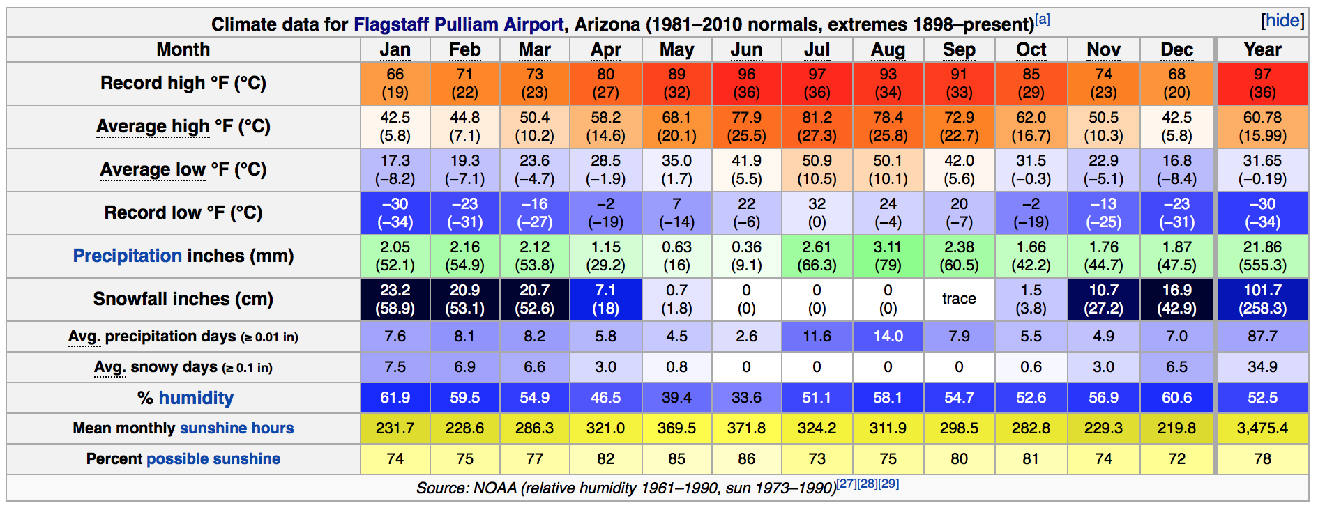
Typical Climate
LDT is located within the Coconino National Forest on the Colorado Plateau in Northern Arizona, at an elevation of nearly 7,700 ft. As such it has a fairly temperate climate with cool and snowy winters, warm and dry springs and autumns, and typical Arizona monsoonal summers. Temperatures can vary by more than 20˚C from day to night, all year round (layering of clothing is important). Please ensure you are prepared for the cool weather. The climate is similar to Flagstaff, though the day-to-day weather can vary drastically. The table below shows the climate data for Flagstaff.
Weather Maps & Predictions
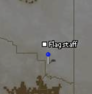
Below are links to weather maps (IR, water vapor, and doppler) for use in monitoring the weather of northern Arizona. To assist in reading these maps the following image (to the right) marks the approximate location of LDT (at the base of the pin).
- IR Satellite: University of Arizona, NOAA, NOAA - fog
- Water Vapor: University of Arizona, NOAA
- Doppler: Payson, Phoenix (two links are provided since clutter after sunset causes noise in these images, thus light rain and clouds are not always distinguishable from the clutter)
- Predicted Weather: ClearSky Chart, NWS Hourly
- GOES-16 Experimental Satellite: GOES-16 . This allows you to view IR updates (5 min normal and 1.5 minute if large storm present) that show water vapor, cloud cover, radar activity, and snow/ice.
Your best resource for weather information is your TO.